Has anyone found a way to let iOS 17 Maps know that you're driving an EV? Haven't found it yet..
Become a MacRumors Supporter for $50/year with no ads, ability to filter front page stories, and private forums.
iOS17 | Apple Maps Thread
- Thread starter MozMan68
- WikiPost WikiPost
- Start date
- Sort by reaction score
You are using an out of date browser. It may not display this or other websites correctly.
You should upgrade or use an alternative browser.
You should upgrade or use an alternative browser.
- Status
- The first post of this thread is a WikiPost and can be edited by anyone with the appropiate permissions. Your edits will be public.

Has anyone found a way to let iOS 17 Maps know that you're driving an EV? Haven't found it yet..
Pretty sure it is part of CarPlay only…
Set up electric vehicle routing in Maps on iPhone
On iPhone, Maps can help you plan trips that include stops for charging your electric vehicle.
support.apple.com
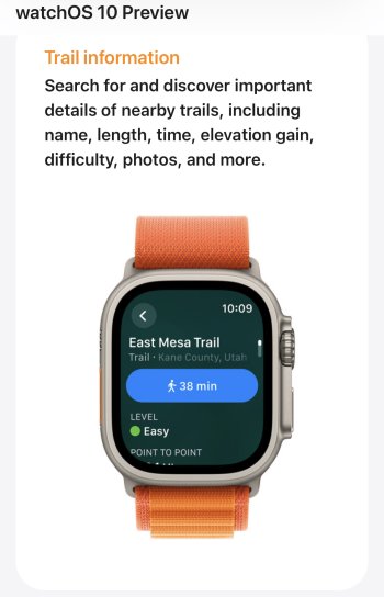
In the description for WatchOS 10, under the section “Hiking” it describes trail maps as well as topographic maps. It’s unclear if this is a feature of the compass app, or if there may be a component in Maps. Are there any signs of trails or topographic layer in Maps?
Attachments

If you want to cut down on data usage for whatever reason and use an offline map instead, do you have to turn on airplane mode or something?
OhPretty sure it is part of CarPlay only…
Set up electric vehicle routing in Maps on iPhone
On iPhone, Maps can help you plan trips that include stops for charging your electric vehicle.support.apple.com
That’s quite ironic. The best-selling car in the world, arguably, is the Model Y.. and Tesla does not support CarPlay directly
Oh
That’s quite ironic. The best-selling car in the world, arguably, is the Model Y.. and Tesla does not support CarPlay directly
Well..yeah.
Tesla, Rivian…soon to be GM…all closed systems that force you to use their maps.
But best selling? Not for long. I think practically every major car company outside of GM (and we’ll see how long that lasts) will partner with Apple in one way or another and have said as much.
"In addition to the new compass feature, we are also updating Maps. Starting in the US, we are intruducing a new topographic map with contur lines, hill shading and elevation details along with points of interests and trail heads." WWDC 1:13:00.In the description for WatchOS 10, under the section “Hiking” it describes trail maps as well as topographic maps. It’s unclear if this is a feature of the compass app, or if there may be a component in Maps. Are there any signs of trails or topographic layer in Maps?
Seems like its an update for Apple Maps.
Yeah I don't think GM realizes just how many people will make a decision based on that. I spend less than 3 hours per day in my car...and some days during the week, I don't get in my car at all. But after having it, I wouldn't buy a car without it!Well..yeah.
Tesla, Rivian…soon to be GM…all closed systems that force you to use their maps.
But best selling? Not for long. I think practically every major car company outside of GM (and we’ll see how long that lasts) will partner with Apple in one way or another and have said as much.
Car with CarPlay vs. Car with CarPlay...buy the car you want and have CarPlay either way! Easy! It just comes down to which car you like more than the other.
Car with CarPlay vs. Car without CarPlay...easy decision! It's a quick way for a manufacturer to lose a surprisingly large number of potential customers.
I've had two Teslas over five years, and there is NO WAY CarPlay would make me shy to own another. However, I kinda cheat..Car with CarPlay vs. Car without CarPlay...easy decision! It's a quick way for a manufacturer to lose a surprisingly large number of potential customers.
I have an arm mount that holds my iPhone magnetically while charging to the top left corner of the Tesla's display. I always use Apple Maps (sometimes Google Maps or Waze) to navigate, and before starting the drive push it to the Tesla. It's nice to have both maps to compare, and I want the Tesla to generally know where I'm going for the occasional FSD(beta) use
But I never use Tesla's maps to steer me, as I find Apple Maps to be much better. It's not CarPlay, but it works just fine. Tesla makes the best rides out there (yep, that's subjective), and their decision to not allow Apple to control the maps etc is a small inconvenience - which turns into a fun comparison tool for me really
PS - Google Maps DOES allow you to let the app know you drive an EV, and even route according to the best energy usage as a preference. Kinda nice, keeping tabs on elevation change and speed priorities (the slower an EV drives, the more energy is saved on the same distances) etc
The only car I'd rather own than a Tesla, these days, is my first.. a '67 VW bus =)))
I've had two Teslas over five years, and there is NO WAY CarPlay would make me shy to own another. However, I kinda cheat..
I have an arm mount that holds my iPhone magnetically while charging to the top left corner of the Tesla's display. I always use Apple Maps (sometimes Google Maps or Waze) to navigate, and before starting the drive push it to the Tesla. It's nice to have both maps to compare, and I want the Tesla to generally know where I'm going for the occasional FSD(beta) use
But I never use Tesla's maps to steer me, as I find Apple Maps to be much better. It's not CarPlay, but it works just fine. Tesla makes the best rides out there (yep, that's subjective), and their decision to not allow Apple to control the maps etc is a small inconvenience - which turns into a fun comparison tool for me really
PS - Google Maps DOES allow you to let the app know you drive an EV, and even route according to the best energy usage as a preference. Kinda nice, keeping tabs on elevation change and speed priorities (the slower an EV drives, the more energy is saved on the same distances) etc
The only car I'd rather own than a Tesla, these days, is my first.. a '67 VW bus =)))
Are you referring to Google’s “eco” mode/route option?
With car charging options still somewhat specific to the vehicle or user preferences in many cases, having actual EV vehicle stats and info provided/shared to Maps either directly from the car or the car’s app is vital in my opinion.
BMW, Ford and Porsche do this now with Apple Maps…maybe more??
Yep, preferring fuel-effecient routes, and signifying your engine as Electric (or gas or diesel or hybrid). Apple should certainly follow suit, this only makes sense. Hey, may as well add a Search for POI along route as Google does nicely as well! Oh, I have other requests and observations too.. but I just don't have the right audience to explain and reason towards any effectual change.. unless someone from the Apple Maps team is here!Are you referring to Google’s “eco” mode/route option?
With car charging options still somewhat specific to the vehicle or user preferences in many cases, having actual EV vehicle stats and info provided/shared to Maps either directly from the car or the car’s app is vital in my opinion.
BMW, Ford and Porsche do this now with Apple Maps…maybe more??
It would be ideal if any modern car would give all stats and info to any given mobile device, agreed. That's part of the reason I use both always. The Tesla knows itself and its distance projections and charger stations pretty well, so that's covered.
I remember a photo years ago of Woz that had him using something like five or seven different navigation systems as he drove.. I'm kinda like that with an iPhone and a Tesla =) hehe
I had a dream last night about the topographic Map on my Apple Watch and that it was a clue to how DCE will be released for the entire USA as part of the beta in July....so...there's that....
Has anyone found a way to let iOS 17 Maps know that you're driving an EV? Haven't found it yet..
I've got a Ford Mustang Mach-E and it, the Lightning, and the Porsche Taycan are the only ones that support this feature as of now. When you connect your iPhone to the infotainment, it lets you set that you have an EV and then the maps show what your battery level will be at the end of a navigation session. It's pretty nice.
The best part is that your car settings also go over to macOS, so you can create routes with charging stops natively in macOS to plan ahead. Pretty slick.
Pretty sure BMW ev’s as well. It’s just that in some cases you need to set it up with the OEM’s app to synch properly.
I’m seriously considering an EV now due to lack of distance and drive time…but only if it’s CarPlay compatible.
Sooo...do we know yet *exactly* how the offline maps will work? I've already read that when downloading maps in a DCE area, that Maps will only download the "basic" map look to save on space, which makes sense.
It was also revealed that the "offline" maps will update automatically (as far as POI info, traffic, etc.) when you're in an area with a signal.
Sooo...just as an example. I'm going to Las Vegas in October. Las Vegas is a DCE area. If I decide to visit the Valley of Fire State Park, which I *know* is in a fairly large no-signal area, I would download that "region" of the map so I can properly navigate back to Vegas afterwards. Let's say my map "region" being downloaded includes a chunk of Vegas proper.
On my way back, upon receiving a signal again, would Maps continue utilizing the "offline" map already downloaded? Or would it automatically switch back to the "online" DCE map? And then if I lose signal again for some reason, switch back smoothly to the offline map look?
Sooo...do we know yet *exactly* how the offline maps will work? I've already read that when downloading maps in a DCE area, that Maps will only download the "basic" map look to save on space, which makes sense.
It was also revealed that the "offline" maps will update automatically (as far as POI info, traffic, etc.) when you're in an area with a signal.
Sooo...just as an example. I'm going to Las Vegas in October. Las Vegas is a DCE area. If I decide to visit the Valley of Fire State Park, which I *know* is in a fairly large no-signal area, I would download that "region" of the map so I can properly navigate back to Vegas afterwards. Let's say my map "region" being downloaded includes a chunk of Vegas proper.
On my way back, upon receiving a signal again, would Maps continue utilizing the "offline" map already downloaded? Or would it automatically switch back to the "online" DCE map? And then if I lose signal again for some reason, switch back smoothly to the offline map look?
I’m pretty sure it will go to DCE.
Offline is for when you are actually “offline”…once Maps has any sort of signal, it should download latest traffic, POI’s, detailed Maps, etc.
Honestly, I would only use this when traveling abroad and haven’t experienced an offline area in many years.
I know some people do, but I simply don’t live in an area without enough coverage to use it.
There is one gripe I have with Apple Maps. As a user in the US...I'm sure people outside the country will find issue with what I'm about to say (and I will agree with anyone who does that, especially because there's a LOT of catching up to do for other countries, and your complaint would definitely be bigger than mine)!
Now onto my gripe...listening to new feature announcements...while still waiting for features from a few years ago to be available. Look Around is what I'm waiting on, and I think that's the only one left. Look Around was announced in 2019. Still waiting. I wonder if I'll get the topographic data before I get Look Around (and I live in a pretty flat area, so that should be...interesting to say the least) 😂 I live close to a Look Around coverage area and that area is also covered by the Detailed City Experience. I work in that coverage area, so at least I get to experience the DCE for a portion of my commute, which tides me over for a bit! The DCE kicks in as soon as I get to the interchange that I exit the highway from on my way to work. From that point, I have about 3 more miles of driving. So for about 3 miles (and a whole whopping 10 minutes of my commute), I get to experience the DCE...and it's great!
For those in other countries that are waiting for a heck of a lot more than I am...I definitely feel bad for you and hope you get caught up sooner rather than later!
TheYayAreaLiving 🎗️
Suspended


Apple has just released the new map data in Slovakia, Hong Kong and Taiwan. None of these countries seems to have the look Around feature.


I thought I was seeing things last night, but noticed that on iOS17, the arrows have changed on Maps.
Went back to the ios16 thread to confirm.
Here is Maps on ios17.
![bebe0e9983cd843cc764a8e44106b1ba.jpg]()
![e1c59bc872974ae53f001f75da2bdd45.jpg]()
Here’s one of my pics from the ios16 thread for comparison.
![233564e0b5b2b83260c74ca410f5c2bb.jpg]()
Here’s a CarPlay shot
![4dc05f6f088435d1531b5b181567c9bb.jpg]()
Went back to the ios16 thread to confirm.
Here is Maps on ios17.


Here’s one of my pics from the ios16 thread for comparison.

Here’s a CarPlay shot

Last edited:
Maps in the VW thinks I’m over 4 hours away in Atlanta…hmmmm
![1e8c4b3cd0c0164949be94c0c5b59c29.jpg]()
![89ce95ea69ca24ad487426cf0d8f6aa4.jpg]()
Quick unplug and plug back in fixed…and now wondering if started from my WiFi at home for some reason?


Quick unplug and plug back in fixed…and now wondering if started from my WiFi at home for some reason?
I’ve had some weird glitches occur where Maps “remembers” something after closing, and tries to remember it when reopening after a force close.
One time I was looking at Switzerland and exploring rail stations (for a friend’s trip later this year). I closed Maps completely and went down to my car to navigate somewhere. When I set my destination, Maps tried to get directions to my destination NOT from my current location….but from the train station in Switzerland. And when I tried to cancel, I got this:

Also, I once in a while get a glitch where…well, I have no idea what this is.

One time I was looking at Switzerland and exploring rail stations (for a friend’s trip later this year). I closed Maps completely and went down to my car to navigate somewhere. When I set my destination, Maps tried to get directions to my destination NOT from my current location….but from the train station in Switzerland. And when I tried to cancel, I got this:
Also, I once in a while get a glitch where…well, I have no idea what this is.
I just realized I never responded to your post, but yes...topographic data is obvioulsy there and utilized in the DCE areas to show elevation detail (and of course, trees added as well). Hopefully this add means DCE across the US sooner rather than later.In the description for WatchOS 10, under the section “Hiking” it describes trail maps as well as topographic maps. It’s unclear if this is a feature of the compass app, or if there may be a component in Maps. Are there any signs of trails or topographic layer in Maps?

Register on MacRumors! This sidebar will go away, and you'll see fewer ads.