Become a MacRumors Supporter for $50/year with no ads, ability to filter front page stories, and private forums.
All Devices Updated Apple Maps
- Thread starter Aussi3
- WikiPost WikiPost
- Start date
- Sort by reaction score
You are using an out of date browser. It may not display this or other websites correctly.
You should upgrade or use an alternative browser.
You should upgrade or use an alternative browser.
- Status
- The first post of this thread is a WikiPost and can be edited by anyone with the appropiate permissions. Your edits will be public.
Looks like we've got some new data! It's actually kind of interesting how you can see exactly where the cutoff is for new/old data!
Interesting...and it looks like it goes all the way to the northern CA border.
[doublepost=1531976000][/doublepost]
Last image in the post above...iOS12...the walkway just above MLK Dr. should continue to the left of the street that breaks off to the top of the map. Clearly visible in the satellite view...and Google Maps has it.
Makes me wonder why it isn't there?
Still some work to do....Walking directions would come to a sudden halt there.
Walkway changed with latest update...looks like missing side I mentioned is there now...but missing on the other side??
Good to see the data is changing at least...
Interesting...and it looks like it goes all the way to the northern CA border.
[doublepost=1531976000][/doublepost]
Walkway changed with latest update...looks like missing side I mentioned is there now...but missing on the other side??
Good to see the data is changing at least...
Hopefully it keeps getting better with more and more people using wish it could roll out quicker lol but I know it’s such a big task
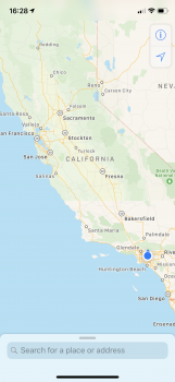
Cheating but took a few screen shots in Mojave since it is easer. This is the southern edge in California and (about) the top half is the new mapping data.

Looks like Apple chose high tide.


Apple seems more liberal on ephemeral water.


One of these is wrong (forgot to check satellite).
Looks like Apple chose high tide.
Apple seems more liberal on ephemeral water.
One of these is wrong (forgot to check satellite).
So, with Apple already releasing the detail for Northern CA now instead of in the Fall as originally stated just a few weeks ago, does anyone feel we may be getting a faster rollout of other areas before iOS12 launch?
I was originally surprised they would allow Waze and Google Maps on CarPlay before rolling out their improved Maps.
I was originally surprised they would allow Waze and Google Maps on CarPlay before rolling out their improved Maps.
I'm not sure I would read much into Northern California, given its their home base and they probably have mapped the heck out of it for their Autonomous Vehicle program. Slightly curious that they delivered early, but it was probably ready to go even when they released San Fran. My ears would really prick up if they released enhanced tiles from areas other than NoCal.So, with Apple already releasing the detail for Northern CA now instead of in the Fall as originally stated just a few weeks ago, does anyone feel we may be getting a faster rollout of other areas before iOS12 launch?
I was originally surprised they would allow Waze and Google Maps on CarPlay before rolling out their improved Maps.
I'm not sure I would read much into Northern California, given its their home base and they probably have mapped the heck out of it for their Autonomous Vehicle program. Slightly curious that they delivered early, but it was probably ready to go even when they released San Fran. My ears would really prick up if they released enhanced tiles from areas other than NoCal.
Yeah...I guess...but that is REALLY early. I guess we will see (or someone who’s willing and has time to research) if any other areas have changed.
Someone please screenshot various areas of the US in iOS 11 to see if they change...I’m too lazy to...
I cheated and used Mojave. MUCH faster and easer....Someone please screenshot various areas of the US in iOS 11 to see if they change...I’m too lazy to...
I cheated and used Mojave. MUCH faster and easer.
I don't have a Mac anymore (company wouldn't allow it)...but if you can, do like 10-20 screen shots of the country as close up as you can see like the state of CA...easily see the "break" from new data to old.
Again, I assumed "Northern CA" would mean just a slight expansion beyond the bay area, not the WHOLE northern half of California.
I'm hopeful they may add some other cities outside of California, or maybe the rest of California, on the next update. I'm heading there in a couple of weeks, so I'll get to try it live either way.
I'm still wondering what happened to the walking path that you pictured in your first posts...it has disappeared completely (between MLK and Middle Drive W). I originally criticized that it didn't continue West across Middle Dr...and now the whole walking path is gone...wtf??
Actually it looks like it goes to the Oregon border and even about 20 miles into Nevada....Again, I assumed "Northern CA" would mean just a slight expansion beyond the bay area, not the WHOLE northern half of California.....
Actually it looks like it goes to the Oregon border and even about 20 miles into Nevada.
View attachment 772318 View attachment 772317
Nice....I did notice the fact that it went to the Northern border. Didn't think to look East to see how far it went.

Can someone tell me if the new version of Apple Maps has those little pop-ups like Google maps telling you of a faster or slower alternative while you are driving on a route?
Living near New York City with so many choices of highways I find this to be the most important feature missing from Apple Maps that prevents me from using it. It is great when you are driving 80 miles an hour to glance at the screen and realize that taking the Long Island Expressway will save you 8 minutes just by glancing at one of these little square pop ups.
Apple Maps have these now?
![5x1lmfvpexqy.jpg]()
Can someone tell me if the new version of Apple Maps has those little pop-ups like Google maps telling you of a faster or slower alternative while you are driving on a route?
Living near New York City with so many choices of highways I find this to be the most important feature missing from Apple Maps that prevents me from using it. It is great when you are driving 80 miles an hour to glance at the screen and realize that taking the Long Island Expressway will save you 8 minutes just by glancing at one of these little square pop ups.
Apple Maps have these now?
I haven't had to use that as stated, but it seems to do a pretty good job of recalculating and giving a faster route when available. Will be interesting to see how this may improve with their own data and possibly more people utilizing Apple Maps.
Either way, as I have stated before, their routing and estimated time has always worked well for me...just hoping for a major improvement in POI data and parsing.
Actually it looks like it goes to the Oregon border and even about 20 miles into Nevada.
They're doing this by county and regional jurisdiction, typical of the industry. Those locations in Nevada are - north to south - Washoe County, Carson City, and Lyon County.A couple of 'weird' places in Nevada.
I'm watching the progress in a Mojave container, the updates are showing up in "light mode view" but not yet in "dark mode view", toggled in the Mojave Maps app.
And, it's far easier to "stitch" mapping areas together once there's a common base point set and IGAs are in place (intergovernmental agreements - planners are the most snittiest people I've ever worked with, especially with tourism and funding at stake) before letting a private company represent their region.
The current version of Apple Maps has this. You just have to be in Overview mode (on CarPlay). Used it today in precisely the area you want it for.
You can also enter an overview mode from the iPhone itself, by tapping on the black top navigational bar while driving.
The current version of Apple Maps has this. You just have to be in Overview mode (on CarPlay). Used it today in precisely the area you want it for.
Yeah, that’s the problem, “overview” mode is of no help when you are in the fast lane on the Long Island Expressway doing 80 mph.
With Google maps I don’t have to even touch the screen, just glance down and it will show me a major highway choice and which one is faster with the pop up. If what you’re saying is that Apple Maps requires me to click a button to go to some overview that is not what I’m looking for and would be a disappointment.
It doesn’t though...you CAN do that, but it will also automatically find the fastest route for you if it changes and give you that option.
Yeah, that’s the problem, “overview” mode is of no help when you are in the fast lane on the Long Island Expressway doing 80 mph.
With Google maps I don’t have to even touch the screen, just glance down and it will show me a major highway choice and which one is faster with the pop up. If what you’re saying is that Apple Maps requires me to click a button to go to some overview that is not what I’m looking for and would be a disappointment.
Even in overview, it still gives routing directions. I agree with you, however: it’s most useful in turn by turn mode. If I recall correctly, it was there in the iOS 11 betas (at least) and then disappeared.
Even in overview, it still gives routing directions. I agree with you, however: it’s most useful in turn by turn mode. If I recall correctly, it was there in the iOS 11 betas (at least) and then disappeared.
I’m really not sure what the issue is here.
You are given the route options when you start your route. Apple Maps automatically reroutes you to the fastest route. I’m not sure what one would want to choose while driving??
I’m really not sure what the issue is here.
You are given the route options when you start your route. Apple Maps automatically reroutes you to the fastest route. I’m not sure what one would want to choose while driving??
Sometimes the fastest route is only faster by 2 minutes and is less safe and/or less convenient than just staying the course.
For example, here in the NYC area, the most direct way from New Jersey to Long Island when coming off the George Washington Bridge is the Cross Bronx Expressway. An indirect way that can often be faster is the Bruckner Expressway. The Cross Bronx is just a straight line. The Bruckner is a series of turns and on/off ramps, more complicated.
So when I'm coming off the GW Bridge and there are 12 lanes of traffic converging around pothole-laden arteries going to NJ, the Bronx, Westchester, Manhattan, and Queens in a Death Race 2000 mix of cars and trucks and taxi's, I need to make a split-second decision. No time for taps, no time for distractions, literally a split-second glance at the iPhone screen.
And here's where Google Maps shines. I can look at the turn by turn display that's sitting there, see the blue line and the recommended route, but sitting right there on greyed line is the alternate route along with that rectangle thought-bubble telling me that it's recommending the complicated Bruckner but I can stay on the simple Cross Bronx which is 2 minutes slower. Boom. Staying on the Cross Bronx. A little longer but far less complex. Same for the Long Island Expressway (trucks) and Northern State Parkway (no trucks). Or the Throgs Neck Bridge vs. the Whitestone. Or the Cross Island vs. the Clearview. On a single trip from NJ to Long Island I could get there on 6 different highways and 4 different bridges/tunnels.
That is why Apple Maps cannot replace Google Maps for me. In the NYC area we are always trading off arrival time for the safer or more convenient highway. It's not just about one recommended fastest route. We make quick decisions on the fly as we approach a decision point. And in dangerous spots I can't tap a screen. And the Overview is so zoomed out you can't see the road name either. So it can't be in Overview, has to be in Turn By Turn.
Lol! You’re never going faster than 5 mph on the Cross Bronx. Plenty of time to make a decision!

Lol! You’re never going faster than 5 mph on the Cross Bronx. Plenty of time to make a decision!
Hah...that’s why I asked...born and raised in the NYC/NJ area...one already knows which the best way is. Maps app simply tells you which is fastest and would alert you if there was a MAJOR reason not to use one route versus the other (accident, road closure, etc. )
The examples mentioned (potholes, trucks, curvy, exits, whatever...) are from experience, not any sort of app. But if it works for you, stick with it. Sometimes it’s just one small feature that makes a difference.
Every single highway in the NYC area is “Red” 90 percent of the time though whenever I’m driving through there...hah
You could leave now...not TOO bad at 6:30 am....

Apple

Lol! You’re never going faster than 5 mph on the Cross Bronx. Plenty of time to make a decision!

LOL, yes, perhaps a bad example.
A few miles later in the journey when the Cross Bronx opens up, you have about 20 seconds to decide between the Throgs Neck or the Whitestone, and then a few minutes later a decision between the Cross Island and the Clearview, and then a few minutes later a decision between the Long Island Expressway and the Northern State Parkway. 6 different roads, 36 different outcomes, all takes place within a 5 minute span.
And this is where Google Maps shines. Because at 80mph instead of a) blocking the screen and telling me its chosen the fastest path for me or b) forcing me to tap the screen and fumble to zoom in to decipher, Google Maps just puts the little speech bubble up there so at a glance I can see what I really need to know- how much faster/slower is it if I take the Clearview instead of the Cross Island? Hey, it's only 2 minutes slower but it's more direct and it's the route my wife is the most comfortable with, she doesn't have to feel pressured to go a different way.
With iOS12 giving us Google Maps in Carplay this should be the solution I've been looking for in my BMW's. Same speech bubble pop-up during turn-by-turn but on a bigger screen and no more need to use a vent clip to hold my phone.
Register on MacRumors! This sidebar will go away, and you'll see fewer ads.